Saturday, November 5, 2011

Fantastic Airport!

Every pilot has a favorite airport.  Some like the scenery, some like challenging conditions or approaches, and some like the amenities.  This past weekend I found what has become one of my favorite airports of all times.  Dekalb-Peachtree(KPDK) in northern Atlanta.  KPDK is a large, busy feeder airport that supports northern Atlanta in Georgia.  What has made me fall in love with this airport is its charm, in that it’s a pilot’s airport.  First off, we stopped and parked at Epps Aviation on the West side.  The service was fantastic to say the least.  They are located right off the runway (very close to the runway, which I will discuss shortly) and they had our rental car waiting for us before we even got to our parking spot.  The ground crews were super friendly and helped us to unload the plane, so that we could quickly depart.  The facilities were clean, updated and homey.  All of the staff was fantastic.  After arriving we decided to get a bite to eat for lunch.   We were directed to go eat at the “Downwind Café” at the other end of the building.  Little did we realize that it was right next to the runway, overlooking the approach end of RW34.  The food was really good and the view was awesome.   To be able to sit that close to the runway, watch jets and small planes land while eating a burger, is paradise for a pilot!  Right next to the restaurant, the airport has a viewing stand that overlooks both runways and also has a really nice playground for the children.  This is a fantastic stop for those cross country trips since everything is right on the field.  There are also plenty of instrument approaches as well.
Part of the ramp in front of Epps

Downwind Cafe

Epps Aviation

The deck overlooking RW34 from Downwind Cafe

Playground

Tuesday, September 6, 2011

Flight to Airventure 2011, Oshkosh, WI

Flying to the Oskosh Airshow, also known as Airventure, is a dream of every pilot.  It is the world’s largest airshow and becomes the busiest airport in the world for the seven days that the airshow is going on.  I have been to this airshow now maybe five times, however this is the first time that I have actually flown into KOSH to enjoy the show and camp out under the wing of the plane. 


This trip had bad timing written all over it, but I was determined to make it this year, since I missed it last year.  Just prior to this event, I had moved my family from Platte City, MO down to Fort Rucker, AL for a new assignment.  After getting to Alabama, I took my family to Destin, FL and then on to Panama City, FL from which I would catch my commercial flight to Memphis and then on to Kansas City.  Once at Kansas City, I met up with my brother Bil, a MD-11 Pilot for UPS, who on this trip would assist me in navigating the challenging arrival into OSH as well as enjoy a day of the show with me.  It was an honor to have him fly with me since we don’t get to fly together very often.  In Kansas City, one of my Army buddies Reed picked us up and took us to the Downtown Kansas City Airport (KMKC), where we would fly out of for the very last time in Holly.  We departed KMKC for a quick 5-minute flight to KGPH to get some fuel since the pumps were broken again at the downtown airport.  After topping off the tanks, we departed at 3:15 PM for the 1:45 minute flight to Oshkosh.  Our flight was IFR, GPS direct from KGPH to the DLL (Dells VOR) and then VFR on to the RIPON arrival point (which is also a small town), to FISK and then to KOSH itself.  Airventure publishes its own NOTAMs for this airshow to handle the thousands of aircraft that fly into KOSH every year.  IFR arrivals are limited to a slot system and is really limited only to turbo prop and jet aircraft.  The VFR arrival procedure also known as the FISK Arrival has all VFR aircraft approach the RIPON waypoint.  As a pilot approaches this point, he turns his transponder to standby (ATC can’t handle all the blips), and pilots must listen to the ATIS to get the current conditions on the arrival procedure, field conditions, and parking status.  If there are many aircraft coming at the same time, ATC will put them into one of two holds.  The first hold is just SW of RIPON around Green Lake.  The second hold is around Rush Lake, just NE of RIPON and West of Pickett.  Planes will arrive at either one of two altitudes.  The first group will arrive at 1,800’ and maintain 90 knots or less.  The second group for planes that can’t fly that slow, will arrive at 2,300’ and maintain 135 knots.   
<>  <> 
FISK VFR Arrival & Holding Procedure


Once you arrive at RIPON the idea is to find an aircraft that is the same speed as you and follow him in at 90 knots and maintain at least ½ mile separation.  If you can’t keep the separation, then you need to peel out and come back around and reenter.  This is what happened to us as we approached.  It was busy, but not busy enough to have to hold, so we found a white high-wing tail dragger and I slowed the Cirrus down to 90 knots (using 50% flaps), but we were starting to eat him up, so I peeled out to the North and reentered behind a faster brown high-wing tail dragger.  Once we spotted him, we followed the rail road tracks NE towards FISK and maintained our distance behind the brown high-wing.  As we moved along the arrival procedure, it was interesting to hear ATC getting after people to follow directions as published in the NOTAM – like “fly over the rail road tracks.”  Really people, how hard is it to do that?  Keep in mind though that you are not actually talking to ATC since they don’t want people talking on the radio.  Once you get to FISK, they will identify you and ask you to “Rock Your Wings” to acknowledge your instructions.  Our example was something like this:  “white low-wing over FISK rock your wings,  good rock, turn to a heading of 090 and follow Hwy N, contact tower on 126.6.”  The brown high-wing aircraft was sent the same direction, so we continued to follow him, however as we approached the crosswind leg at the south end of RW18R, he started to slow down and ATC got after him because we were about to eat him for lunch.  Next came the approach, which was really cool as well.  Since we were landing on RW 18R we were told to expect a long and or long approach.  Originally as we turned base towards the Blue Dot we were told to land on the Yellow Dot however at the last minute we were instructed to land on the Pink Dot and then “land before the Pink Dot if able Cirrus,” which we did.  We touched down and turned right into the grass.  It was awesome!  I also have a really cool video of it and it’s neat to see how low we were turning base to final to land.
Once on the ground, you put up a sign in your window that tells the ground crews where you want to go.  In our case we put out a GAC (General Aviation Camping) sign and followed all the flaggers.  It was amazing how well orchestrated the ground volunteers are that marshal us around to the different areas.  I was guided all the way around the airport to a place called “The North 40.”  We ended up in row 533 which was right next to the road on the end and right next to the showers.  We couldn’t have asked for a much better spot.  That night I stayed with my brother, but the following days I spent camped out in the North 40.  Staying at Air Venture was really cool since there is just so much to do.  Everyone there is an aviation fanatic, you will find that everyone wants to just hang out and talk planes and flying.  I met some great people that were neighbors to me.  During the evenings there is much to do from watching movies to attending seminars on many different topics.  There are some exhibits open late as well.  My first night there (Sunday night) I was asked to attend a free social put on by Cirrus Aircraft that was awesome.  Free food and beverages and I even got to talk briefly with Dale Klapmeier one of the founding brothers of Cirrus Aircraft.
<> 
Bil & I just after landing (Parked in the North 40)
Planes, planes & more planes
My "campsite"  (Red building in background was the showers)

My neighbors


Another amazing thing that I got to do was attend the Tribute to Bob Hoover interview.  Bob Hoover is an amazing flying legend and war hero.  His stories about WWII were amazing and almost unbelievable.   There are few people like him left in the world and I’m really glad I got to attend this interview.

After four days of fun, I decided that I needed to get moving since bad weather was coming.  My calculations (and the NOAA weather predictions) showed that on Wednesday afternoon, OSH would be getting hit with a huge thunderstorm.  Many of my fellow pilots were planning on departing early Wednesday morning, so that they wouldn’t get stuck on the ground from the rain soaked turf.  When we woke up, we were surprised to see that the rain was already upon us and it rained constantly for about five hours.  I did some last minute shopping since I couldn’t get an IFR slot clearance.  Around noon time I was barely able to taxi in the wet grass and had to keep my speed up to prevent getting stuck.  I made my way though the wet grass and mud to RW13 which was being used as a taxi way and followed the guidance to line up behind a bunch of other aircraft on taxi way A for departure on RW27. 
Waiting for the rain to pass
VFR Departure Procedures
In line waiting to depart

Throughout the departure process you don’t use your radios as all.  I put a sign in my window that said “VFR”, to show that I was departing using visual flight rules and as I got to RW27, I was told to “line up and wait” on the left side of the runway while a yellow Columbia 400 lined up and departed on the right side.  As soon as he was wheels up, I was cleared to take off.  The interesting part about the departure procedure is that you must fly runway heading until clear of the Class D airspace and you must stay at or below 1,300’ MSL or 492’ AGL.  This is basically like flying nap-of-the-earth for 4-5 miles which was really fun.  I followed a Piper Lance and the Columbia until the Columbia and I got right next to each other and then did a little informal formation flying until we were clear of the area and all the arrival traffic.  Once cleared, we waved to each other, he peeled left and I went full throttle and quickly climbed up to altitude to get clear of any incoming traffic arriving.  Once at altitude, I proceeded direct to Southern Wisconsin Regional (KJVL) to get fuel and eat at the airport café. 
My informal flying partner
After stopping for lunch and fuel at KJVL, I departed for Smyrna, TN (KMQY), a 2:15 flight.  I stopped here for the night since I got a late start and I since I could really use a good night sleep.  Total flight time for the day was just over four hours.  I parked the plane at Smyrna Air Center and got a room at the local Holiday Inn Express.  The next day, I had a beautiful day to fly the final leg to Dothan, AL.  My last leg of just over two hours was very uneventful as I descended through the cumulous clouds to land at our new home at KDHN.  This was truly an amazing trip and I look forward to doing this many times in the future!
Descending into Dothan, AL


Wednesday, June 22, 2011

iPad, changing aviation one app at a time

After months of deliberating over spending the absurd amount of money on an Apple iPad, I finally took the plunge and bought one. I had been eyeing these since they first came out and I have tried several Sony e-readers and even a Kindle, but none of them showed approach plates very well and were just too cumbersome to use. My wife bought the first iPad when it came out and I downloaded some plates just to see how it worked and it was simply amazing. My experience with her iPad was limited though since she loved it so much, she wouldn't let me use it all that much. It was only a Wi-Fi only version, so it had limited aviation applications since it had no GPS.

So for aviation purposes, you really need to get a 3G version from either AT&T or Verizon. This provides you with the ability to use it anywhere you need to, which is extremely helpful if you ever fly into a small airport with limited facilities. The 3G version also has the built in GPS with allows for the use of numerous aviation programs. Although I have yet to try it, I'm told that you can track your flight while in the air as well. If you purchase the Georeference package from Foreflight, you can even have georeferenced instrument approach plates that will show you where you are at, as you fly an instrument approach.

There are numerous applications out there for the iPad now, but so far here are the ones that I have/use. Some of these are iPhone applications, but others have been "upgraded" to iPad versions:

Aeroweather - This is by far one of the best weather apps out there! It is easy to use and a great reference tool for pilots.

CirrusPerform - This is a must have app if you own/rent/fly a Cirrus aircraft

FlightPlanForm - Although this app has a few glitches, it is good to help guide a briefer when calling in a flight plan

AOPA Airports - A great source for airport data

ForeFlight - This is an AMAZING application! It has more functions than you can ever imagine!

JeppTC - This app is only good if you have already paid the outrageous subscription for digital approach plates for your CMAX or other digital chart programs. If already have CMAX, then you really don't need an iPad unless it's to be used as a back-up.

AirCheck - This is a handy app for making digital checklists.

FlightPlan - This app is decent and has some good conversion tools

FltPlan - Another airport data app.

DUAT - an ok, but bland app for flight planning. You can link into DUAT using ForeFlight or Garmin Pilot My-Cast and have a better tool.

Garmin Pilot My-Cast - This is another very good flight planning/all purpose aviation tool.

PilotWiz - This is a pretty good flight planning tool. I especially like the weight and balance functions since it allows me to create my own.

LogTen Pro - This is an ok app, but as a professional pilot it might be a very handy tool. As a PP it doesn't fit the bill for me.

MyRadar Pro - This is a great radar tool!

myE6B - Another flight planning tool.

These are only a few of the applications available to use for aviation. The iPad in my opinion is a game changer just like XM - NEXRAD Radar and GPS. It provides pilots with lots of information for flight planning and also allows a pilot to have all the necessary tools like IFR approach plates, enroute charts, and sectionals, all without having to lug around 20lbs of books, or having to find a place that actually has those products for sale. Oh and if you get stranded due to bad weather, you can watch movies, listen to music, surf the internet, play games, or check your e-mail. Other than the price, the iPad is a perfect tool for pilots at any level of aviation.

Sunday, June 19, 2011

Flight Review

Today (18 JUNE 11) I took my first ever Flight Review (previously referred to by the FAA as a biennial flight review, or BFR). This is a flight review required by the FAA (14 CFR 61.56) for pilots to be considered "current to fly" and must be completed every 24-calendar months for active holders of a U.S. Pilot certificate. The flight review consists of at least 1-hour of ground instruction and 1-hour in-flight instruction with a qualified flight instructor. The FAA and instructors seem to be quick to point out that it is not a test. There is no pass or fail criteria, although the instructor giving it can decline to endorse your log-book that a flight review has been completed.

Being this was my first one (my previous requirement was met by completing my instrument rating) I was a bit nervous since I didn't know what exactly to expect. My instructor Joel was the same instructor that I did my Cirrus transition training with, and a fantastic flight instructor, so there wasn't any worries from that aspect. I just wasn't exactly sure what to expect.

Since I had to meet Joel at Gardner (K34), I departed KMKC at 0645 for the quick 10-minute flight to Gardner. This turned out to be kind of fun since the paved runway there, RW 8, is only 2960' x 39' which being narrow makes it seem like you are flying way too fast on final. The flight over was uneventful and I linked up with Joel to execute the flight review.

N779WC at Gardner Municipal (K34)
Ground Training - For this part of the exam I had prepared a XC flight from KMKC to KOMA and we used this as a basis to "chat" about IFR procedures, Airspace requirements, and flight rules. Instead of getting a machine gun list of questions, Joel turned the discussion into an exam without really making it feel like one! It was quite awesome really. We talked for about 1.5 hrs and then stepped out to the plane.

Flight Training - We loaded up in 9WC and departed on RW26 and headed out to the west to do some basic maneuvers. We did stalls, steep turns, slow flight and then shot an ILS into New Century RW 36. After this we did some touch and goes into RW 8 at Gardner which were a blast because of the narrow runway and then because of the quick turn to the north in order to stay clear of the Class-D airspace. When looking at the airspace you would think that it would be right traffic, but it's not! When looking at the Garmins or MFD it actually shows you inside of the Class-D airspace, however Joel assured me that we were safe and not actually inside the controlled airspace. After a couple of these, we stopped and the flight review was complete. It really turned out to be a pretty fun training experience!

Wednesday, June 8, 2011

Trip to the Hamptons (2010)

On Monday 13 September 2010, I took my family (Mandi, Mason-almost 4yo, and Tyler-3 weeks old) with me to Watertown, NY for work. This was a landmark trip for us in many ways. First off, it was the longest cross country trip I had taken to date (2,526 NM). Second it was the longest trip my family had taken to date. Lastly we had a three-week old baby with us! All of this posed some interesting challenges for us, but overall it would end up being quite the adventure. Because of the age of Tyler, we were limited to no more than 8000’ cruising altitude, so as not to hurt his newborn ears. This also makes traveling in warm weather a bit bumpy since we couldn’t climb over it to the smooth air sometimes when needed.
Mandi and Tyler in cruise mode
Mason occupied with a movie
We departed KFLV in the morning and headed for our first stop Celina, Ohio (KCQA) about 2:30 flight time. We filled up on fuel and I took the courtesy car into town to get some food for lunch, while Mandi tended to Tyler. After lunch we departed NE towards Cleveland, OH and then followed V14 towards Syracuse. Just prior to Syracuse we were give a “cleared direct to KART” and turned out over Lake Ontario direct to Watertown. As we approached Watertown, there was a storm moving down from Canada, so we raced to get in and then get the plane unloaded and secured before we got wet. Flight time for this leg was just over 2:30 hours. All was good though and we called the airfield manager to come let us out of the gate and give us the keys to our rental car. We drove to our hotel and I conducted my business for the next couple of days.

Late morning on Wednesday, we departed on our “vacation” over to Long Island to site see and to visit my friend Alex. Part of this trip was to fulfill part of my bucket list by landing in every state one-time enroute. My planned route was to fly from KART to Rutland, VT (KRUT) about 40 minutes to the east, however as we began our VFR approach it got to be pretty turbulent and the wife was NOT happy, so I aborted and we continued on for another 23 minutes to our next airport at Laconia, NH (KLCI) at which we landed on RW26 and stopped for the night due to all the turbulence. Laconia turned out to be a really awesome little vacation town and a fantastic airport. The manager gave us his courtesy van free of charge and we drove into town and found some dinner and then a hotel. We both really enjoyed the area and hope to come back for a visit when we had more time. We had breakfast the following morning at a place called Kitchen Cravings that was to die for! Unbelievable food and it’s right across the field on the opposite side of the airport.

The next morning we departed KLCI for Sanford, ME (KSFM), 11 minutes flight time, where I did a touch and go on RW14 and then headed south for 28 minutes to Provincetown Municipal (KPVC). KPVC is a very unique airport in that it is on a sandy point allegedly has the shortest RW with an ILS (3,500’).

Approach into Provincetown Municipal
We circled the point and sucked in the amazing scenery and then landed on RW25 to check it out.  By this time it was getting pretty late, so we decided that maybe we should head for Martha’s Vineyard, MA, which was only 20 minutes away, since there was an airport café there and we wouldn’t have to bother with getting a cab or rental car at Provincetown.  So we loaded up and departed for KMVY where we landed on RW24 and got some lunch.  It was really hard to believe that we were at Martha’s Vineyard!
Approach into Martha's Vineyard

After lunch we departed for South Hampton (KHTO), 30 minute flight time, where we had to dodge some outgoing traffic in order to land on the short runway since there was significant wind.  We landed on RW16 (2,060') and parked it for the night. 
South Hampton Airport

We were fortunate enough to get a really nice Buick Enclave that was never picked up and got a great deal on it. We then drove over around a bit exploring and waited for my friend Alex to fly over from Bridgeport, NY to Montauk (KMTP) and have dinner with us. We linked up with Alex at Rick's Crabby Cowboy, which was adjacent to KMTP and ate dinner. Rick’s is a really nice restaurant right off the airport and on the bay. The owner even came over and sat with us for a bit since he knew Alex. Great food and great hospitality! I hope to come back here again someday. After dinner, Alex flew me back to KHTO in his Cirrus SR20 where my wife met up with us and we went to the hotel for the night. As it turns out, there were no reasonable hotels near us, so we drove well to the west closer to NY since we wanted to stay in a place that we knew like the Hilton Garden Inn.

Since some bad weather moved in, we decided to stay a second night in the Hampton’s and we drove around and explored a bit. The Hampton’s are an interesting place in that there is a lot of money around you, yet it doesn’t seem like a very clean area like you would think. The roads are narrow and busy and there aren’t any chain stores or restaurants on Long Island. You really don’t get to appreciate Long Island though until you fly around it.

One of our most memorable stops was to visit the Montauk light house, which is at the very most eastern end of Long Island.  It was cool to see it in person and walk up inside this old light house.

Another cool sight was the Grumman Goose and Cessna Caravan owned by none other than Jimmy Buffet, seen here at South Hampton.
Jimmy Buffet's Grumman Goose

Jimmy Buffet's Cessna Caravan w/floats
The morning of our departure, 18 SEP 10, I had to stop at a few more states that were on my "bucket list" prior to heading back to Kansas City.  One more note on South Hampton (KHTO) that pilots need to know.  They charge exorbitant prices for everything AND THEY CHARGE FOR TOUCH & GOs!!  I DO NOT RECOMMEND USING THIS AIRPORT!  Instead fly to Montauk (KMTP) or Mattituck (M21) or Francis S Gabreski  (KFOK).  After paying our fees, we departed KHTO and flew north over the bay to a really cool airport right on the water called Elizabeth Field, Fishers Island, NY.
Approach into Elizabeth Field


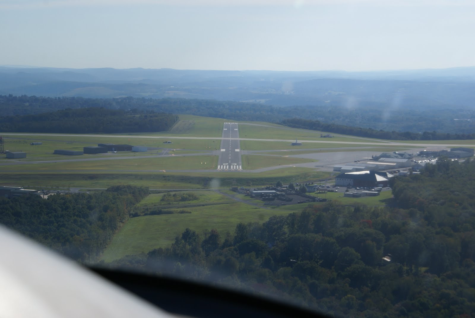
This had a really cool approach and we flew in over a bunch of boats all watching us come into this relatively short airfield and land on RW12 (2328'). We stopped to check the place out and to use the restroom and then departed to the NE to do a touch & go at Westerly State, RI (KWST) on RW14. This place was crazy busy and there was flight training traffic going all over the place, so we did a quick touch-down and departed to the north to Willimantic, CT (KIJD) Were we landed on RW27 and stopped to file our IFR flight plan. This was also a very busy airport and quite frankly had fairly poor facilities. The weather was ok, however there was a broken cloud layer around 3000' and I wanted to get above it. We filed and I figured that I would pick up my clearance in the air or at least that was the plan. We took on a little fuel and departed on RW9 since the winds were calm and that was the active RW. I turned to the west and tried to call approach control. After numerous failed attempts and us bouncing around in the low level turbulence, I decided to head for a controlled field and get my clearance straightened out. The closest Class-D was Hartford, CT (KHFD), however as I approached the airport another aircraft reported engine problems and they directed me back east and then to the north. As we approached the airport, there were a lot of planes flying around and I could see the airport in the distance. The problem though was that the airport diagram didn't look the same as the airport, it was actually the exact opposite! Both of my GPSs were showing me in the right spot as was the MFD and the paper chart I had, yet the airport didn't look right. The tower then cleared me to land and I was adamant about where I was and what I was cleared to do, yet the tower said nothing. Then just as I was about to turn final I noticed what appeared to be a huge stadium at the end of the runway and then I noticed "Xs" on the runways. Just then both Mandi and I realized that there was TWO airports next to each other! We then landed safely on RW20 at Hartford and pulled off the runway. I told that tower about my dilemma with my clearance and they directed us to a parking ramp while they tried to figure it out.
We sat with the doors up, engine running, dying in the sweltering heat, on the tarmac for almost an hour trying to get our clearance figured out. Since I was very unfamiliar with the area and wasn't used to the Boston type accents of the controllers, I must have had them repeat the clearance 14 times until I finally understood where we were going. Mandi and I had the charts out and were searching all over for the route that we had been assigned. Our final clearance was as follows: KHFD-PWC-V106-LHY-KJST. Once we figured it out, we departed on our 1:43 minute flight and all was fine. I had never received a clearance like this before, so it was a great learning experience, I just wish I had done it under different circumstances. After we got out of the NY airspace, it was smooth flying and we landed at Johnstown, PA on RW23. As it turns out, the John Murtha Johnstown-Cambria County Airport is a fantastic and beautiful airport and home to one of the 56th SBCT Battalions. We had a beautiful approach into this airport and the scenery was just amazing. We topped off with some fuel and decided that our next stop would be our last for the night since it was an 1:30 minutes away. We took off and headed to Hamilton, OH (KHAO), which is in northern Cincinnati. We decided that with all the traveling that Mason deserved a little waterpark time, so we landed here for the night and got a taxi to take us to Coco Keys indoor waterpark. We landed at night on RW29 and found a taxi to get us to the hotel.
Approach into John Murtha Johnstown-Cambria County Airport , PA
Coco Keys was a pretty nice place, but I must say I'm more partial to Great Wolf Lodge in Kansas City. We ordered in some dinner from room service and crashed for the night. The next morning Mason and I went down and played in the pool for a few hours and then it was back to the airport for our final leg.

Hamilton Airport is a really nice little airport with a nice new modern FBO. The service was fantastic and we will definitely stop there again. We packed the plane and departed on our final leg back to Kansas City (KFLV). Flight time planned was 2:46 for this final leg, and we had smooth flight the entire leg.

Although at times, trips like this can be kind of stressful, overall it was a very fun and scenic trip. We got to see some really pretty terrain from the air and from the ground, and I got to fly to eight more states on my “bucket list”. I would love to come back with more time and do some exploring. The east coast is an amazing place with lots to do and it’s all very accessible by air if that is your mode of transportation. The Airspace is very busy (compared to what I’m used to), so you need to be ready for the quick flight plan changes and the fast talking controllers. We found all ATC controllers out east to be great. On my flight plans I had added in the remarks box “Baby Tyler on board, gradual climbs and descents required” and we had several controllers as us how Tyler was doing and if he was enjoying the flight. Overall, it was a great experience!
2,526 NM and eight states.  It was a grand adventure!


Friday, May 20, 2011

Flight to El Paso, TX

This morning at 0625, 2 May 2011, I departed the KMKC airport on an IFR flight plan to Portales, NM (KPRZ) and then on to El Paso, TX (KELP) or a TDY business trip to Ft. Bliss. This was my first adventure to the Southwest of Kansas City and was also my first experience with high altitude airport flying. My weather was pretty decent the entire flight and I was VMC the entire way to KPRZ, however there was a massive front just to my south that was wreaking havoc for the Dallas area.
The rest of my team was flying out commercial for DFW and then on to El Paso at 0815. This trip for all of them turned out to be a big mess and arrived almost three hours after I landed. “Stack Air” made it through with no issues. I flew at 10,000’ the entire way to KPRZ, which was a 2:45 flight time. Even though I could have gone non-stop, I chose to stop at Portales since it had the cheapest fuel in the area ($4.90), which is still outrageous, but much cheaper than the KELP $7.10. The Portales Municipal airport was a nice quant little airport with two runways, but only one GPS approach. As soon as I landed the manager came out and helped me fuel the aircraft and I changed into my uniform since it was much colder than I had expected. Apparently they had a freak cold front move through and so the temps all dropped down to the 30s. I topped off my tanks and took off for KELP. This was my first “high altitude” take off since the airport elevation was 4,078’ and it was interesting as to how lean the engine had to be in order to get it to run decent. Takeoff roll was a bit longer than normal, but overall it wasn’t all that big of a deal. This flight was not GPS direct like the previous because of all the restricted airspace and MOAs around KELP, so I flew the V208 airway over Roswell, NM and then over a couple of small ridges and into El Paso. Roswell looked really cool since there are a whole bunch of aircraft all mothballed out in the desert. (Sorry the picture just doesn’t do it justice)
The decent into KELP was uneventful although a little bumpy and windy since the desert was starting to warm up and the approach path was right over some small ridges. I was cleared for the visual for RW 26R and came in with no issues. I parked 9WC at Cutter Aviation and tied her up for my weeks stay. The team at Cutter were very prompt and friendly and proved to be a very nice FBO.
My departure on Friday 6 May 11 homebound was relatively uneventful. I departed on RW 26R with an immediate heading correction to the east to avoid crossing into Mexican airspace and then direct to Alva, NE (KAVK), 2:43 flight time. While I leveled off at 9000’ I noticed a large dark cloud forming in the distance in front of me. What was odd about this was that my NEXRAD showed nothing! As I got closer I started thinking about asking for some deviation even though my radar still showed nothing. ATC then called me up and reported a cell directly in front of me with light and moderate precipitation and then asked me if I wanted to deviate, which I do. I deviated 30 degrees to the right and then once cleared went back direct. On the way back the MOAs were not active, so I was able to fly more direct than when I came to El Paso.
Once I was clear of the storm cell, I dawned my oxygen cannula and climbed to 13,000’ to try to benefit from the stronger tail winds. The rest of my trip was relatively boring until I got close to Alva and the controllers started vectoring me all over the place due to the high density Air Force training area around Vance AFB. At one point the controller asked me if I wanted to maintain IFR because he would have to take me well out of my way to keep me clear of traffic. He said that if I went VFR, he could get me in quicker. Since the conditions were VMC, I said I could do VFR and I could do whatever it takes to help him out. He then cancelled my IFR and asked me to rapidly decent 2000’ and to change headings. At that time I watched two T-38s go screaming by below and to my left, which was pretty cool. After a few more vectors, I was cleared direct to KAVK, where I had a challenging windy approach and stopped for gas.

Alva Municipal Airport is nice little quiet airport and Erik, the airport manager came out and helped me fuel the plane. I had called him prior to departure to confirm his fuel prices, however when I landed he said that they were about $1.50 more than what he had quoted me. He apologized and sold me the fuel for the phone price and then gave me the courtesy car to go into town and get some lunch. After lunch, I departed on my 1:15 minute flight back to KMKC with no issues. Overall it was a great flight and once again proved the value of flying GA over commercial air service. On a side note, the rest of my team got delayed again at both KELP and KDFW and made it back to Kansas City about three-hours after me!

Sunday, March 20, 2011

Staying Current

For those of you that are Instrument rated, you are aware of the regulations to stay legally current in order to keep flying in IMC (Instrument Metrological Conditions). According to FAA Regulation 14 CFR Part 61, to be current, you must have performed and logged, within the previous six months, instrument experience in the following areas: at least six (6) Instrument approaches, conducted holding procedures, and have intercepted and tracked courses using navigation systems. Some pilots do this by knocking out all the requirements in one flight and others break it down over the six month period. If you fly frequently, then it just kind of happens, and you remain current. Keep in mind though there is a difference between currency and proficiency and just because you are current, doesn't mean that you are proficient!

This leads me to my flight yesterday. I fly a fair bit with 210 hours last year and I averaged 19 hours a month, which is pretty good. I flew a lot of major cross country trips from Kansas City to Minnesota, Wisconsin, New York, Georgia, Tennessee, Kentucky, Alabama, and Texas. On almost every long trip I took, I logged some IMC time and had to shoot many instrument approaches. However since last November I haven't been flying nearly as much due to the bad weather we were having here in the midwest (lots of ice and very cold), as well as an electrical issue that had my plane AOG for a while and then I had to conduct my annual Inspection, which also took a few weeks. That all being said, my instrument currency was getting close to "expiring" and well my proficiency kind of sucked!

Yesterday my buddy Frank met me at the airport to get up and get my currency up to date and to work on my proficiency. We departed KMKC around 0800 to get some approaches done on a nice fairly warm sunny day. It was a little windy with winds around 11-15 knots on the ground out of the east and much higher at altitude. Our first stop was to shoot the ILS RW33 at Lawrence (KLWC). This approach came up on us fast being that we had a tail wind of 42 knots at 2500'. We departed from KMKC under VFR (Visual Flight Rules), yet we were well inside the Class B airspace, so we had to be a bit careful and not break any airspace on our way to Lawrence. My set-up for this approach was a bit behind and I flew through NEWBN the initial approach fix a little and headed out bound for the procedure turn. Another issue that put me a little further behind the airplane was that the S-TEC55 autopilot that I was flying at the time, wouldn't load the approach and gave me a "FAIL GPSS" indication, so I had to continue to fly by hand. We believe this to be because of the more than 30 degree angle it was sensing when I activated the approach. My typical methodology is to fly on autopilot until I'm inbound on the approach and turn it off before the FAF (Final Approach Fix) and then hand fly the approach to the ground. With the autopilot failing, I hand flew the entire approach. Because of the winds being so high and out of the East, this made for a challenging yet fun ILS! The approach went ok, but I could tell that I was a bit rusty. We went "missed" at the MDA (minimum descent altitude) and then headed for Topeka Billard Municipal Airport (KTOP) via the Topeka VOR. KTOP does not have approach radar, so we contacted the tower and they told us to report inbound from BILOY for the ILS RW13. We pretended we were getting vectors to final and then reported BILOY inbound for a coupled ILS approach. This time I set up early and had the autopilot fly the entire approach. It was really windy, but it executed the approach well enough with a little help from me to keep it from over correcting and we landed with no issues. At this point it was off to the airport cafe for some fantastic breakfast! :-)

After breakfast we decided to fly to the Topeka VOR (TOP) and execute some holds and then execute the VOR RW22 approach back into KTOP. The winds were 130@12 and RW13 was the preferred RW, but I asked for RW4 since it would take us directly to the VOR and I could also practice a cross wind take-off. We departed with no issues and I set up for the VOR hold at TOP. This is where the fun began (remember I said the winds were 42 knots at 2500') as I attempted to cross the VOR at 2800' to set up for a tear drop entry. The winds were so strong that I got blown to the west of the VOR and had to compensate more east to get into the hold. Because of this massive deviation, we decided to make a right turn (east) and basically do a direct entry and then head straight in for the VOR because we were so badly off course. We then crossed the VOR and made the easterly turn and entered the hold. We made two race tracks around the hold using massive corrections to compensate for the winds and then shot the VOR RW22 approach with a circle to land RW4. My next issue happened that lack of proficiency caused, where my Navigation radio (G430 GPS) decided to stay suspended in the hold, while I began to execute the decent. So fighting with the wind, I had to reset the approach in the radio while executing the approach. This was a real pain in the butt, but I had the VOR tuned in and could fly the necessary heading, but if it would have been IMC, I most likely would have gone missed and then re-executed the approach. I descended to minimums and then began a close left downwind RW22 over the field and then brought the plane around for a low approach over RW4. This was a really fun approach because of all the complexity of changing headings at the VOR upon exit of the hold and then adding the close circle to land and low approach.

Next we departed the pattern, climbing to 5500' and direct to East Kansas City (3GV). I called up Kansas City Approach and they cleared me through the Class B and gave me vectors to the GPS RW9. After being cleared I executed the GPS RW9 non-precision approach and landed with no issues to get some fuel. This was my first time into 3GV on a full stop landing and I was a bit shocked at how poor the runways were with all the bumps and humps. This place has prop strike written all over it! We fueled up and decided to execute a soft field take-off, so as to help reduce any prop strike incidents and departed back to KMKC. While we had been flying we were watching a small storm cell moving towards Kansas City and it now appeared to be just to the south west of the city and moving in fast. Shortly after landing at KMKC it began to rain and then actually snowed!! It was a good thing that we finished when we did or the weather could have been really ugly.

So after executing four approaches, holds and tracking navigational aids and I am current for another "six months", since I had executed two approaches in December. Needless to say, I am NOT proficient and need to get back up and do some more practice. I am feeling a bit rusty - still safe, but rusty. With the summer weather approaching, hopefully I will get some more flying time in soon. It was a great day to fly and the winds made it challenging, but once again this is why I love flying so much, because you have to stay proficient and fly often to retain the skills that you have learned. Staying proficient is EXTREMELY important to me, since I often fly with my family on board and I owe it to them to keep them safe at all times.

Sunday, March 13, 2011

Electrical Issue Fixed

While 9WC was getting its annual done, we took off the main alternator and shipped it off to Aircraft Systems and had them conduct an IRAN (Inspect and Repair As Necessary).    As it turns out I had a bad rectifier that had some connections that came unsodered.  Aircraft Systems also did some upgrades to it and sent it back.  TJ at Aircraft Systems said that they see a lot of alternators off of Cirrus that have this issue.  It is the same alternator that is also used on Beechcraft as well, but they don't see as many as they do the Cirrus.  He believes that the damage is caused by two things on a Cirrus.  The first issue is that most Cirrus come with a very light weight propeller that cause more vibrations around the engine area and the second issue is that the cowling on a Cirrus are pretty tight to aid in aerodynamics.  This tightness doesn't allow the alternator to get enough air over it, so when a plane is on the ground, the alternator can overheat.  Once the plane is airborne it isn't an issue, so TJ recommends that people not put a huge load on the systems while on the ground under idle.  Since the annual is done I took the plane up for a test flight and all is back to normal.  No more annunciator lights or low volt warnings.  I'm glad that fixed the problem, because the next steps in trying to solve the issue would have gotten fairly expensive.

Friday, March 4, 2011

Cirrus Airframe Parachute System (CAPS)


The Cirrus Airframe Parachute System also known as CAPS provides the Cirrus aircraft with an additional level of safety. It is not guaranteed to save the occupants in the event of an accident, but it definitely provides another option, where as no other aircraft on the market can.

As of January 30, 2001, there have been 29 known CAPS activations. Of those activations, 26 deployments are considered to have been "saves" that involved 50 survivors with one fatality. This figure also does not include the one unborn child who was also saved in CAPS pull #13. There were four other activations however that were not successful deployments, resulting in five fatalities and two serious injuries. The four unsuccessful deployments involved one activation at very high speed (likely in excess of 270 knots, twice the deployment speed), one activation at too low an altitude to fully inflate the canopy (witnesses report 50 to 200 feet above ground), another activation where the rocket took an unusual trajectory resulting in a failure to extract the parachute, and a mid-air collision where the parachute was likely activated by impact forces. The rocket trajectory anomaly was investigated and an airworthiness directive was published requiring a modification of the CAPS rocket assembly. Although any loss of life is tragic, 50 "saves" is pretty amazing and thanks to this new safety measure, that is 50 less fatalities in General Aviation.

For more information on each individual accident, please go to http://www.cirruspilots.org/Content/CAPSHistory.aspx