The 9th of May was both a sad and exciting day
for me. This was the first day of a long
journey (2,452 NMs) to deliver my “mistress” to her new owner in Hillsboro,
Oregon. The previous night I had the
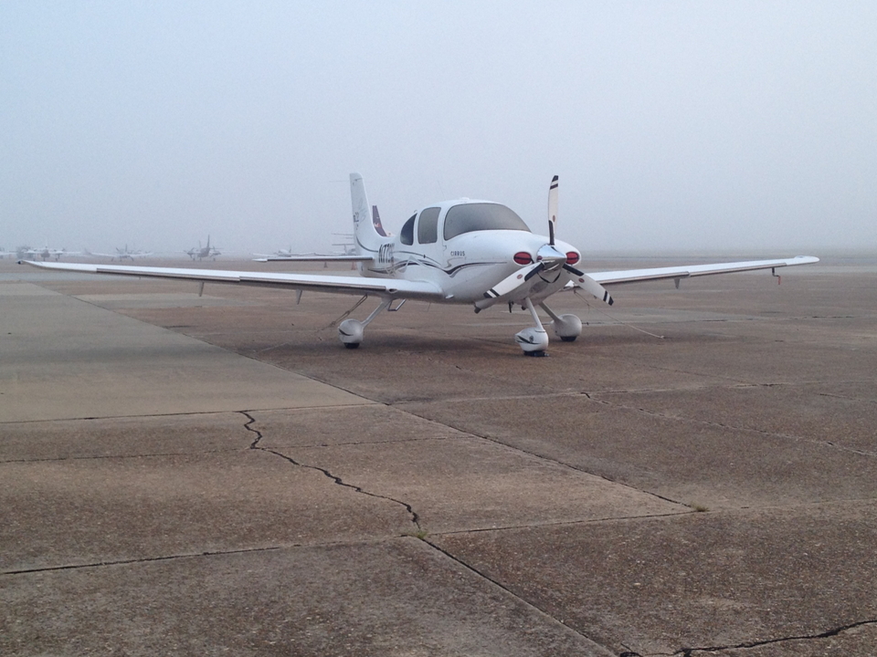
plane topped off with fuel and parked it on the ramp outside of Aero-One
Aviation (KDHN) in preparation for my early departure. I had intended to get up early and be
airborne by 0600 to ensure I had plenty of time to navigate any weather and to
allow me to get to Fort Collins, CO to visit with some friends. As I arrived at the airport, I quickly
realized that I was going to be stuck on the ground for a while since heavy fog
had rolled in and visibility was too low to take off.
 |
| On the ramp at Dothan, AL |
 |
| Awaiting the fog to lift |
After waiting for a little over an hour, a Baron taxied by
did its run up and took off. I could
barely see the aircraft as it passed by me on the runway, but the pilot
reported that the tops were only at about 50’ now and that the runway
visibility was broken. This looked
promising to me, so I jumped in, started her up and taxied to the end of RW
32. After conducting my run-up, I
received my clearance, taxied onto the runway and took off at 07:19am. Sure enough, I rotated and before I knew it,
I was above the fog in perfectly sunny skies!
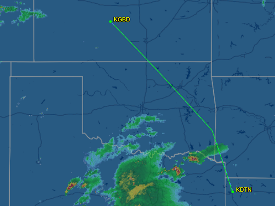
My first leg of five for this trip was to Shreveport Downtown (KDTN) 495
NMs to the West. Originally I was hoping
to fly a more direct route, however bad weather over Kansas City didn’t support
this, so I decided to go to the west before cutting north and try to stay clear
of the thunderstorms and try to get behind them. My flight time to KDTN was 2:53. This leg was relatively uneventful as I
cruised along at 10,000’, however there was a cell moving from west to east
towards Shreveport and as I approached the clouds started to build. The closer I got, the worse it got and about
thirty minutes out, I was in the clouds and had to shoot a localizer approach to
RW 14. The approach went fine, but the
clouds were almost to minimums which made it important to get gas and get out
of there quickly.
 |
| Leg one - Dothan to Shreveport |
After arriving at KDTN, I got fuel and found out that there
was a nice little café in the terminal of this airport, so I went in and got a
decent breakfast before heading out for Leg 2.
This leg would be to the Northwest to Great Bend Municipal (KGBD),
Kansas via the PGO VOR, which I chose as a waypoint to direct me away from the
approaching storm. After quickly eating
breakfast and getting fuel, I departed on RW 14 in ever dropping ceilings and
did a climbing right turn up into the clouds and direct to PGO. What was interesting about this is that I
entered the clouds at around 500’ and was then in solid IMC up until approximately
9800’ where I broke out just prior to my assigned 10,000’ cruise altitude.
 |
| Just reached cruising altitude |
 |
| Leg two - Shreveport to Great Bend |
This second leg of this trip was also fairly uneventful with
a flight time of 2:46 minutes and 505NMs.
Only as I reached my destination did things start to change. About thirty minutes from Great Bend the sky
opened up to just broken clouds and the air started to get a little more
turbulent, which is fairly normal as the day goes on and the temperatures
rise. As Kansas City Center (KCC) started
to bring me down, they told me to expect the visual. Shortly thereafter is when my communications
started to act up. The lower I got, the
more broken KC Center became. At one
point, KCC reported the airport to my 1200 and 15-miles, to which I reported
that I was VMC and looking for the airport, however very shortly after that I
lost all communications with KCC. I
continued to call to cancel IFR, but didn’t get any response. At two-miles from the airport I was still at
4000’ and almost on top of the airport.
I had reported that I had the airfield in sight and wanted to cancel
IFR, however I had no communications with KCC, so I chopped the throttle and
turned to the Southwest and entered a short approach to land on RW 35. My thought process was that I had already
reported that I was VMC and after that call I had reported numerous times that
I wanted to cancel IFR, so I figured I would just land and immediately call KCC
and report that I was safely on the ground and that I had lost contact with
them. Being that I was VMC, I felt this
was a safe move and all would be fine.
However…
Shortly after landing and taxiing in to the FBO, I shut down
and the lineman gave me a piece of paper and told me that I needed to call KCC
immediately (shit). I then called KCC
and was told that they were "confused as to what my intentions were" and that I
broke regulations by doing what I had done.
He did confirm that they had heard me say that I was VMC, but couldn’t
understand why we had lost comms. I was
informed that they had great coverage in that area and that there was no reason
for me to not be able to talk to them. I
explained my rationale and everything seemed to be ok. The only thing that I think I could have done better was to squawk 7600 (no radio) on my transponder to let them know that we had lost comms. Had I done that, it probably wouldn't have been an issue - lesson learned. I guess I was busy trying to figure out how I was going to lose all the altitude and not overfly the airport. At the time that was my logic, but now it's just pretty silly and I should have known better.
After my brief discussion with KCC, I took the courtesy car
into town and got some lunch. One of the
cool parts of this trip was the fact that this airport used to be a training
base for B-29s during WWII. There was a
pretty cool monument on the airfield as well as some of the old buildings and
one of the huge hangers still there.
It’s a shame that there isn’t more stuff there to look at, but the fact
that I found this accidently is still pretty cool.
 |
| B-29 Memorial |
After a late lunch, I departed on my last leg of the day at
1601 for Fort Collins Regional (KFNL), flight time 2:26. This would be the hardest part of the trip
due to weather concerns. While the
clouds were broken at KGBD, I departed VFR in VMC and started my climb up to
10,000’ again. I called KCC to pick up
my clearance in the air and once again, no contact until I was up to
6,000’. The controller seemed a bit curt
with me, but I received my clearance and all was well.
 |
| Leg three - Great Bend to Fort Collins |
Shortly after reaching 10,000’ I noticed more and more cells
building and I also noticed the cloud layer below me slowly climbing. Since it was late in the day the build-up was
starting to tower, making things a bit more interesting for me and forcing me
to ask for a lot of deviations. I
figured that since I was going West altitude would be my friend, so I put on
the oxygen cannula and asked for 12,000’ and then eventually 14,000’. As I climbed and flew west the clouds continued
to rise above me. This would have been
fine except for the fact that as I continued west, I started to hear PIREPs of
planes picking up ice. The last thing I
wanted to was get stuck at 14k’ or higher and then have to descent through
10,000 feet of solid icy clouds, so while I still had a few holes, I asked to
descent to 8,000’ and latitude to deviate both left and right to get through
the clouds. I was cleared to descend and
down I went. I picked my way around and
for the most part stayed out of the clouds, however there was one small benign
looking cloud that I couldn’t avoid and as I went through and the entire plane
instantly had a thin layer of ice on it.
I turned on the TKS anti-ice system and then was out of the clouds
before I knew it. The TKS cleaned up the
wings and windshield really well and I continued on. From that point I took some vectors and then
was put on an arrival procedure to Fort Collins Regional Airport. By the time I got there, it was fairly clear
with patches of build-up and I landed without any issues to complete my leg of
367NMs. Welcome to Colorado, another
state off the bucket list.
 |
| MFD/NEXRAD appears fairly clear... Notice how tight the cells are (NOT good). This is a great example of how NEXRAD can give you a false sense of security! |
10 MAY - Day Two
After a great but quick stop overnight to see an old Army
buddy, I departed Fort Collins Regional for the 2:26 minute flight to Ogden-Hinckley
(KOGD). The morning was perfect, clear
skies and almost no wind, so I knew that flying over the Rocky Mountains would
be pretty safe and relatively easy.
After conducting preflight and taxiing to the end of the runway, I
called Denver Clearance to pick up my clearance. Even through KFNL was an uncontrolled
airport, it was right next door to KDEN, so you have to call them for your IFR
clearances. My plan was to depart to the
north to the Laramie (LAR) VOR and then follow V85 to Medicine Bow (MWB) VOR,
then V6 westbound to Ogden at 10,000’ except at Fort Bridger VOR I would have
to climb to 12,000’ to clear the mountains.
Being that I have built in oxygen in the Cirrus, I could easily climb
higher, but heading west you have lots of wind and I don’t care to wear the
cannula if I don’t have to since they are kind of uncomfortable. From my perspective, even though I was
“crossing the mountains” it should be a pretty easy leg to fly…
 |
| Leg four Fort Collins to Ogden |
I called for my clearance and that is when all the confusion
began. Since this was a busy area, I
should have known that I wasn’t going to get what I wanted, but at the time it
didn’t dawn on me. Approach wanted me to
depart KFNL and fly south to the DEN VOR, and then to the east before going
north. My clearance was read super fast
and after the controller said DEN VOR, I was like WTF. As I tried to digest this, I asked the
controller why I was flying so far south, when I planned direction of flight
was north and it would keep me away from the busy Denver airport. I was told to stand-by and so there I sat
with the engine running looking at the beautiful rocky mountains for about 5-minutes. The controller then came back and asked if I
could immediately climb to 16,000’ direct Cheyenne (CYS), to which I replied no
and was told to stand-by again (apparently he must have thought I was a Turbo). Finally after about 5-minutes he came back
and said that if I could do immediate climb to 14,000’ direct LAR VOR, V85 to
Medicine Bow (MBW), then V6 to Cherokee and to OGD, that would be the closest
he could do for me. I repeated the
clearance and blasted off runway 33 at 8:44am to the north and put on the
cannula as I climbed.
 |
| Fort Collins |
 |
| Me with Cannulas |
 |
| Crossing the "first" pass |
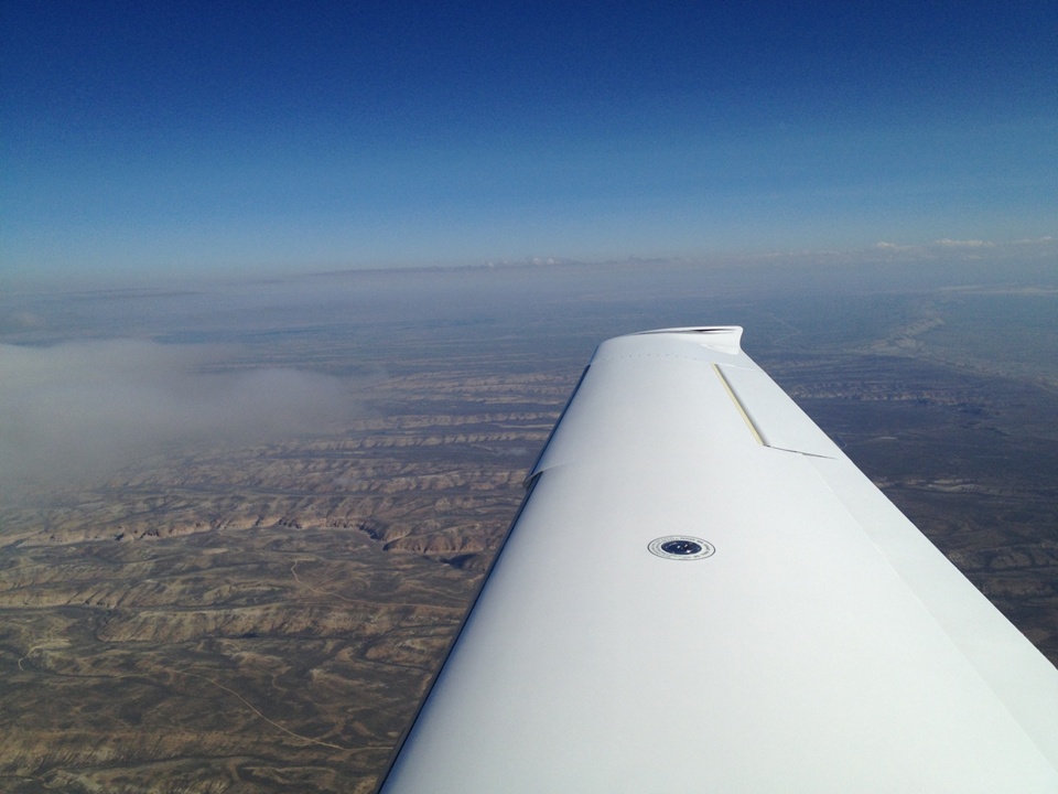
The entire climb was gorgeous with the mountain range off my
left wing and the air was cool and smooth.
I couldn’t have asked for a better morning to fly! As I reached LAR, my clearance got changed
again and I was told to follow V4 to OCS, FBR then on to OGD. I cruised along at 14K for almost two hours
taking pictures like a tourist. I was
concerned about flying the mountains, but in all reality, there really wasn’t
anything to worry about along that route.
The pass was low and the area really wasn’t all that rugged. After getting past the first pass, the
terrain smoothed out and it was really easy going.
From 14K, it was REALLY easy going. Just shy of the mountain range at Ogden, I
came down to 12,000’ and shortly thereafter I crossed the mountain range and
got vectors to the north trying to get me down from my altitude. It took me a while to lose all that altitude,
but eventually I got directed into the airport to land on RW 21. Flight time was 2:26 minutes and 442NMs.
 |
| Ogden on the other side of the mountains |
 |
| Crossing the range |
 |
| Hill AFB in the distance |
 |
| Ogden-Hinckley Airport |
 |
| Over the edge of the Great Salt Lake loosing altitude |
The Ogden-Hinckley airport is a busy, but really nice
airport. With the mountains right behind
it, this has to be one of the most beautiful areas I have ever flown. I stopped at Ogden Mountain Valley Aviation
to get fuel and to get some food. Right
next door is the terminal (that also has commercial service) and has a
restaurant, but I quickly found out that it was way too busy to get any food at
and I needed to keep moving so as to keep my timeline. I ended up having to get a bunch of junk food
out of the vending machines and depart.
 |
| Leg two - Ogden to Hillsboro |
 |
| Great Salt Lake |
The last leg of my journey started at 11:51 as I departed
KOGD for Portland-Hillsboro. This would
be the longest leg of the journey at 643NMs and a flight time of 3:23. I had originally intended to stop at Boise
since that is where my journey with N779WC had begun several years earlier, but
I was on a timeline to get the plane to Hillsboro to its new owner, so I just
decided not to stop. This part of the
journey was by far the prettiest of the entire flight. Departing over the Northeast side I flew to
BYI VOR via the V101 airway, then V4 to BOI, then V500 to UBG with radar
vectors into KHIO. I flew the entire leg
at 12,000’ and enjoyed a spectacular view of Mount Jefferson, Mount Hood, Mount
Adams and even a glimpse of Mount Rainier way off in the distance. It was a beautiful day to fly with only a few
scattered clouds and smooth air. It was a great leg with no issues and I could
just take in the beautiful views and continue to take photos like a tourist.
 |
| Mount Hood |


As I approached KUBG, Portland Approach gave me vectors to
KHIO and things begin to get busy quick.
As I got closer, I tuned in to KHIO tower and noticed that it was an
extremely busy airport with a lot of foreign student pilots not only trying to
figure out how to fly, but also trying to articulate English for the
tower. At one point, Approach gave me an
immediate 90 degree left turn to avoid a PC-12 and then vectors back to the
airport. As I switched over to tower my
traffic started going crazy with “bogies” all over and a little uneasiness
came over me as there was an awful lot of student traffic everywhere. I landed without incident in what I would
have to say was a perfect landing on RW31 and I taxied over to the FBO to see
the new owner standing outside waving. At
that point reality set in that my beloved Cirrus was now someone else’s. Although this was very sad, I was also excited at the same time because I could tell that the new owner was just as excited as I was the first time I saw N779WC, and I knew that he and his family were in for a special journey and that they would enjoy her just as my family and I have.
 |
| Portland, OR |
N779WC was a fantastic aircraft for my family and for our
travels. I flew her 619 hours and landed
in 39 different states in just over three years. I learned a lot about true cross country
flying, dealing with weather, flying actual IMC, and I learned a lot about
myself. Although the journey wasn’t
cheap, I still believe that it was worth every penny! For those that read this and think “owning a
plane is too expensive” in all honesty it really isn’t all that expensive. There are many variable and there are
opportunities for things to be expensive, real expensive. However if you do the research and by the right plane, its really not all that bad. However in my opinion you do need to fly more than 100hrs a year to truly make it financially feasible, but then again that depends on what you get for an aircraft. The shear freedom to be able to take off at a
moment’s notice and go wherever you or your family wants to is truly priceless. I was able to take my family on many trips to
more places then I could have ever dreamed.
We did trips that were impossible by car, or just flat out too expensive
to do by commercial air. The freedom to
travel without your kids getting molested or radiated in commercial airports
was more than enough reason to own a plane in itself. The experiences you gain as a pilot is
invaluable and truly sets you apart from those that just “stay in the area.” So as you can expect, there will be another
plane in this family again and hopefully another Cirrus someday – no question
about it!
 |
| N779WC in her new home |